Know Your Niagara Falls Daredevils: Annie Edson Taylor “Queen of the Mist”

In the fall of 1901 Annie Edson Taylor took a trip that she thought would bring her fame and fortune.  On her 63rd birthday the former school teacher climbed into a barrel.  The hatch was closed and the barrel was set adrift above Niagara Horseshoe Falls.  She began a voyage that day that only a handful of people over the last century would live to tell about.

She began her life in Auburn, NY and grew up with a comfortable lifestyle.  Although her father passed away when Annie was 12, his inheritance left them in a style the family was accustomed to.  At 17 Annie met David Taylor, and after a short courtship they were married.  A baby followed but passed away within days of being born.  At 25 she became a widow after David was wounded in the Civil War. After a stint in San Antonio, Texas as a school teacher, she decided to move back to New York State where she became a dance instructor.  She liked the finer things, and as her parent’s inheritance began to run out she became more desperate to make ends meet.  The thought of living a life with less than finer things literally “drove her to the brink”.

The New York Times, October 25, 1901

WOMAN GOES OVER NIAGARA IN A BARREL

She Is Alive, but Suffering Greatly from Shock

——
Plunges from the Horseshoe Cataract —
— Thousands View the Attempt —
“Don’t Try It,” She Advises Others.
——

Special to the New York Times.

NIAGARA FALLS, N. Y., Oct. 24. — A widowed woman, Mrs. Anna Edson Taylor, safely passed over Niagara Falls in a barrel this afternoon. The trip from end to end was witnessed by several thousand people. The fact that Mrs. Taylor failed to go on Wednesday did not lessen the confidence of the public in her. Still everybody was agreed that it was a foolhardy trip.

It was beyond any conception but her own that she would live to tell the story. But she is alive to-night, and the doctors say as soon as she gets over the shock she will be all right.

This initial voyage over Niagara’s cataract began at Port Day, nearly a mile from the brink of the Falls. From Port Day Mrs. Taylor and her barrel were taken out to Grass Island, where she entered the barrel, and at 3:50 she was in tow of a boat speeding well out into the Canadian current. At 4:05 the barrel was set adrift, and Mrs. Taylor was at the mercy of currents in waters that never before have been know to spare a human life once in its grasp.

From the spot where the rowboat left the barrel the current runs frightfully swift and soon breaks over the reefs that cause the water to toss in fury. The barrel was weighted with 200-pound anvil, and it floated nicely in the water, Mrs. Taylor apparently retaining an upright position for the greater part of the trip down the river and through the rapids.

Fortunately the barrel kept well within the deep water, and except for passing out of sight several times, in the white-crested waves, it was in view for the greater part of the mile. In passing over the Horse Shoe Fall the barrel kept toward the Canadian side at a point 300 feet from the centre.

It dropped over the fall at 4:23 o’clock, the bottom well down. In less than a minute it appeared at the base of the fall, and was swept down stream. The current cast it aside in an eddy, and, floating back up stream, it was held between two eddies until captured at 4:40 o’clock.

As it was landed on a rock out in the river it was difficult to handle, but several men soon had the hatch off. Mrs. Taylor was alive and conscious, but before she could be taken out of the barrel it was necessary to saw a portion of the top away. Her condition was a surprise to all. She walked along the shore to a boat, and was taken down the river to the Maid of the Mist Dock, where she entered a carriage and was brought to this city.

She is suffering greatly from the shock. She has a three-inch cut in her scalp back of the the right ear, but how or when she got it she does not know. She complains of pain between the shoulders, but this is thought to be from the fact that her shoulders were thrown back during the plunge, as she had her arms in straps, and these undoubtedly save her nick from breaking.

In passing over the falls she admits having lost consciousness. While thanking God for sparing her life, she warns everybody against trying to make the trip. So severe was the shock that she wanders in her talk, but there is little doubt but that she will be in good condition within a day or two.

Three doctors are at her bedside to-night. Mrs. Taylor is forth-three years old. She wasborn in Auburn, N. Y., and has crossed the American Continent eight times. During her stay here she has impressed everybody with her wonderful nerve.

The barrel in which Mrs. Taylor made the jouney is 4 1/2 fee high and about 3 feet in diameter. A leather harness and cushions inside protected her body. Air was secured through a rubber tube connected with a small opening near the top of the barrel.

Mrs. Taylor is a school teacher and recently came her from Bay City, Mich. She was born in Auburn, N. Y., and is forty-three years old. She has cross the American Continent from ocean to ocean eight times.

Perhaps Annie’s vanity got the best of her when she knocked twenty years off her age.

The trip over the Falls in a barrel never brought her the money she had hoped.  She died destitute in Lockport, NY April 29, 1921 at the Lockport Home and Infirmary. The Oakwood Cemetery Association donated a grave to honor her place in Niagara Falls history.  She is buried next to fellow riverman Carlisle D. Graham. Also in the same row is Captain Matthew Webb, first man to swim the English Channel, and Francis Abbott, “the Hermit of Goat Island”.

To see Annie’s marker, turn right after entering the gates from Portage Road.  Follow the road on the south side of the cemetery until you come to the first “Fork”.  Annie is in the third row at the point of the “Fork”.

[Source:  http://www.myoakwoodcemetery.com] – Check out their site and visit Oakwood Cemetery, a real Niagara Falls treasure!

Video & Photos: Customs House Phase 1 completion unveiled

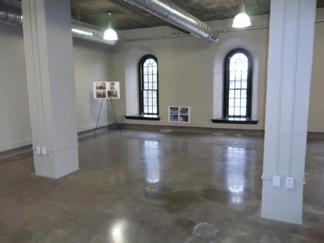
City and state officials gathered in Niagara Falls yesterday to unveil the new historic U.S. Custom House by the Whirlpool Bridge, which is the first part of a new international railway station.

Officials say the new custom house will link to a rail terminal that’s scheduled to be built later this year.

The cost of the renovation was about $2 and a half million and the entire project should be open and ready for commuter travel by 2014.

City officials were jubilant (to say the least) that this phase of the project has been completed and noted that the rest of the project will take equal amounts of hard work and determination in order to complete.  Watch video here:

Tom DeSantis addresses the crowd:


Mayor Dyster speaking about the Custom House and high speed rail:


Photos from the open house:


Photos by Anne Smith:


History of the Customs House

The original building was constructed in 1863 as a full three-story structure and was possibly used as a hotel until purchased by the government in 1867. In 1869, the building was converted to house the U.S. Customs and Post Office. In 1906 the Post Office was relocated into the new federal building and in 1910 the US Customs was also relocated. A newspaper account from 1910 reports it was abandoned July 1 of that year when the Customs Office reportedly moved to the new Post Office Building on Walnut Avenue and Main Street.

During the interim period from 1910 to 1928 the building reverted to other uses. According to one source it was used a button factory during World War I and then around 1924 it was gutted by fire. The subsequent renovation of 1927-8 accounts for the lowered roof and the new front entrance on Whirlpool Street due to the relocation of the railroad loop which rendered the old east entrance obsolete.

The two and a half story stone structure is built into a railroad embankment, and while the north and west facades have entrances on the street level the second story on the south side opens directly onto the railroad tracks. The original building was three stories, but was gutted by fire around 1924. Throughout the years the building has been modified due to changing physical circumstances (the relocation of the railroad loop) and natural disasters (the 1920’s fire).

[Read more here]

U.S. Customs House sneak peek today (Open house 3:30pm – 5:30pm)


You are invited by Niagara Falls Mayor, Paul A. Dyster to tour the newly restored Historic US Customhouse located at 2245 Whirlpool Street (corner of Bath Avenue), Niagara Falls, NY.  Today from 3:30 – 5:30pm.  This open-house celebration marks the completion of Phase-1 of the International Railway Station/Intermodal Transportation Center Project.

Historic Development (paraphrased from National Register of Historic Places Registration Form)

The original building was constructed in 1863 as a full three-story structure and was possibly used as a hotel until purchased by the government in 1867. In 1869, the building was converted to house the U.S. Customs and Post Office. In 1906 the Post Office was relocated into the new federal building and in 1910 the US Customs was also relocated. A newspaper account from 1910 reports it was abandoned July 1 of that year when the Customs Office reportedly moved to the new Post Office Building on Walnut Avenue and Main Street … read more by following link:  http://niagarafallshistoricpreservation.org/node/6

LaSalle resident finds 1950 class ring in backyard; does it belong to you or someone you know?

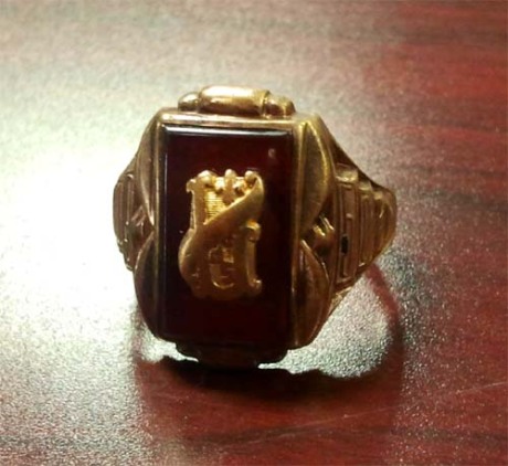
While rototilling his backyard lawn (622 79th Street) in preparation for the upcoming summer season, Niagara Falls resident Brian Lee caught a glimpse of gold while maneuvering the machine through the soil.

This die hard full-of-LaSalle-pride former LaSalle student was floored when upon further inspection, he realized what he found was a small treasure of local LaSalle history – a men’s class ring from 1950 bearing the LaSalle insignia:

Brian Lee is asking the viewership of NiagaraHub for assistance in finding the original owner – the ring is a Jolsten 10k with the initials engraved inside (middle initial D, last initial M… you tell us the first initial for security’s sake).  Anyone have any idea who this ring might belong to?

Hopefully, someone steps forward and matches all information and can reclaim their lost piece of nostalgia!  We will follow up this story and hopefully reunite former student with the long lost ring – please email theniagarahub@gmail.com – stay tuned!

. . .

History All Around Us: Sacred Heart Complex – 1112 South Avenue

Sacred Heart’s origins date back to 1855 when Bishop Timon authorized Fr. William C. Stephens to establish a mission church to be known as St. William’s. This church serviced the growing community of Suspension Bridge (as the North End of Niagara Falls was known at the time). The mission was housed in temporary quarters while a formal church was built. This church was constructed in 1855 and consecrated in 1856 as St. Raphael’s. St. Raphael’s was destroyed by fire in November 1888.

It is believed that an original rectory was built sometime between 1861-1882 and was possibly located at the northeast corner of Superior Street (now Eleventh Street) and South Avenue i.e. the west side of the present day church. Sometime prior to 1888 a school was also built on the east side of the church; this building was later converted to a convent prior to 1897 and demolished prior to 1914. This school was built for the Visitation Nuns.

Construction on the present day church was initiated in January 1889. Fr. Hines moved quickly, and the foundation of a new church, complete with a cornerstone, was laid May 15, 1889. On Sunday, February 18, 1890, the church of the Sacred Heart was dedicated.

In 1895 Sacred Heart purchased the adjacent Zion Lutheran church for $6,500. The 1897 Sanborn map shows that the Sacred Heart church did utilize the former Lutheran church as a school for a number of years. The Lutheran congregation used the proceeds to construct a new larger church for themselves at the corner of Michigan and Tenth Street.

This former Lutheran church was demolished to make way for the present day school (built 1899-1900) and convent (built 1909). Under the direction of Father James Roche, construction on the school began in 1899 and was completed and officially dedicated on March 19, 1900. The cost for construction was $28,000.00. In 1904 funds were raised to replace the church roof and in 1906 renovations were undertaken to the church interior which included new stained glass windows placed behind the main altar. Father Roche was also instrumental with the construction of the present day altar which is alleged to have been copied from a church associated with the Vatican.

In 1909, Father Roche supervised the construction of the present day convent to provide adequate housing for the Sisters of Saint Joseph who were serving at the school. The last building to be built was the present day rectory on Eleventh Street.

Father Thomas F. Gleason (1926-1937) spearheaded some major changes to the physical church as the congregation continued to grow. Significantly, the brick exterior was completely stuccoed, the confessionals were moved to the rear, the altar rail was extended, and St. Anthony’s shrine was abolished to create an exit in the front of the church.

Monsignor John E. Rochford (1943-1960) oversaw regular improvements including: an expanded parking areas, a playground for students, new roof on the church, improved heating and lighting systems, remodeling of the church hall and the installation of the present day pipe organ. One of the last projects undertaken by Msgr. Rochford was the addition to the school, later known as the ‘new school’ located on the north side of the original structure. Construction began in June 1959, and at a cost of $300,000, when completed in February 1960 consisted of six classrooms and an auditorium-gymnasium. The old school building was also renovated and the complex accommodated an enrollment of 900 students in September 1960.


More recent work on the church includes; redecoration of the church interior in 1972 and a two year renovation project initiated during Father Donald Armbrewster Pastorship (1974-1979) which included major structural work both inside and out, interior painting, repair to the organ and installation of a carillon in 1976.

Due to declining enrolment and an overall population loss the school addition was closed in 1979 and in 2001 Sacred Heart School finally closed its doors. The church itself was closed in 2008.

To continue reading more information about Sacred Heart, please click here to visit niagarafallshistoricpreservation.org

[Source: http://www.niagarafallshistoricpreservation.org%5D

What hometown business from Niagara’s past do you miss most?

I have vivid memories of my mother bringing me to the LaSalle Shoe Store (aka “Louie’s) to buy new Hush Puppies for the first day of school.  I remember the giant plaster sneaker they had on the counter and the rows and rows of footwear of all sorts.  I loved that place.

I remember a bit farther down Buffalo Avenue towards Cayuga Drive was Ganci’s Pizzeria… pizza slices for a dollar and a Playboy pinball machine.

I bought my first Walkman (Personal Cassette Player) at Brand Names on Pine Avenue (which then became Niagara Falls Boulevard).

How many quarters did I drop into the machines at Aladdin’s Castle at the Summit Park Mall?  Probably a thousand.  

Rollerskating at Carousel always tops people’s personal lists of their fondest childhood memories.

Grocery shopping at Slipko’s on Main Street?  Super Duper?

How about places like Beverly Lanes, D&K, or The Red Barn?

I’ve heard a million stories about Falls Street back in the 1950s and 60s and wish I could’ve seen the action of a busy weekend with the streets full of tourists and resident shoppers, I think I missed that scene by a decade.

So here at the NiagaraHub, we’d like to continue the polling process, travel back in time a little bit and get a once-and-for-all public answer from our viewership to the question, “What hometown business from Niagara’s past do you miss most?” 

We know that Pizza Oven is your favorite hometown pizza and that Judi’s Lounge serves up the best wings in town, so now we’ll be able to rank another for the NiagaraHub’s viewership’s favorites. Comment on this post and submit your input!

[If anyone has any amazing old photos that they’d like to share, please do!  Send to: theniagarahub@gmail.com]

..

History All Around Us: The Holley-Rankine House

525 Riverside Drive, Niagara Falls, NY

During the 19th and early 20th centuries, the Holley-Rankine House served as the residence of men prominent in the economic, political and social life of Niagara Falls, a city which owed its early development to the abundant power available from the Niagara River. Numerous mills, which had been established along the river in the early 19th century, were by mid-century consolidated into several companies. One of the largest of these was owned by Porter Brothers, a firm created in the 1840s by A. Augustus Porter and Peter Porter, together with George Washington Holley (1810-1897) who was a distant relative of the Porters. Holley, whose family was involved with politics, was elected to a term in the New York State Assembly in 1853. He was later appointed to serve as U.S. Consul in Naples before becoming Deputy Collector of Customs at Niagara Falls in 1865.

In 1855, during his tenure in the state assembly, Holley purchased from Peter Porter a wooded tract of land overlooking the Niagara River, just above the American Falls. On this land he built his substantial villa, which was mentioned in Holley’s will of 1879, and created elaborately landscaped grounds which included carriage drives and an artificial pond. (The landscaping has since been destroyed by the construction of the Robert Moses Parkway.) From this agreeable residence beside the rapids, Holley, who became enamored of local history, surveyed the falls and the surrounding landscape which he described in his book Niagara as “like a beautiful and true, an excellent mistress, (for) the faithful lover may return to it with ever new delight, ever growing affection2.”

After Holley’s death in 1897, the house was unoccupied until 1902 when it was purchased by William B. Rankine (1858-1905). Rankine, who was trained as a lawyer, took a more pragmatic view of Niagara than did Holley. Early in his career he became interested in the possibility of harnessing the falls for the generation of electric power. This interest was stirred in him while he was reading law in the office of A. A. Porter in Niagara Falls. After being accepted to the bar in 1880, Rankine moved to New York City where he established himself as a successful attorney.

In 1890, however, he gave up his practice to devote himself entirely to his dream of utilizing the falls to produce electricity. Drawing upon his New York connections, he became largely responsible for the establishment of the Niagara Falls Power Company which built the famous Adams Power Plant Complex in 1895-1900. The Adams plant was the world’s first hydro-electric plant to transmit power over long distances. Power lines were extended to Buffalo in 1856 and to Syracuse in 1905. This application of long distance power transmission eventually led to the present Niagara Mohawk system which distributes electricity throughout western and central New York. Rankine returned to Niagara Falls in 1899 and he continued to develop his association with the growing hydro-electric industry. In recognition of his service to the city and the state, a bronze bust of Rankine stands on the grounds of the Niagara Falls city hall, dedicated to his memory as “Father of Niagara Power”.

Since Rankine’s death in 1905, the house has passed through several owners, but it has always remained a private residence. In the 1920s-40s it was the home of Frederick Laurens Lovelace, director of the Niagara Falls Power company, and a man prominent in business and banking in Niagara Falls.

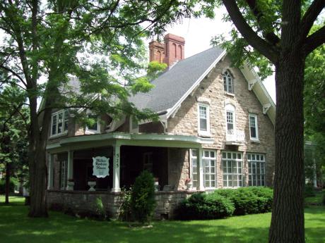
The Holley-Rankine House is significant both architecturally and historically. The best preserved Gothic Revival cottage in Niagara Falls, it epitomizes the style of rural domestic architecture of the mid-19th century that is associated with the writings of Andrew Jackson Downing. The exterior features, as well as the local materials of which it is built and the picturesque setting all seem calculated to illuminate Downing’s contention. In addition, the well-preserved interior woodwork of “warm and dark tones” imparts a “mellow, furnished look” to the rooms that is evocative of the artistic ideals of ante-bellum America.

[From The Niagara Falls Historic Preservation website which can be located here: http://niagarafallshistoricpreservation.org/node/10]

The Holley-Rankine House now serves as a bed and breakfast – see reviews here:  http://www.tripadvisor.com/Hotel_Review-g48261-d122034-Reviews-The_Holley_Rankine_House-Niagara_Falls_New_York.html

Holley-Rankine House 2012 - Photo by Tim Schmitt

History All Around Us: Park Place Historic District (Park Place – 4th Street)

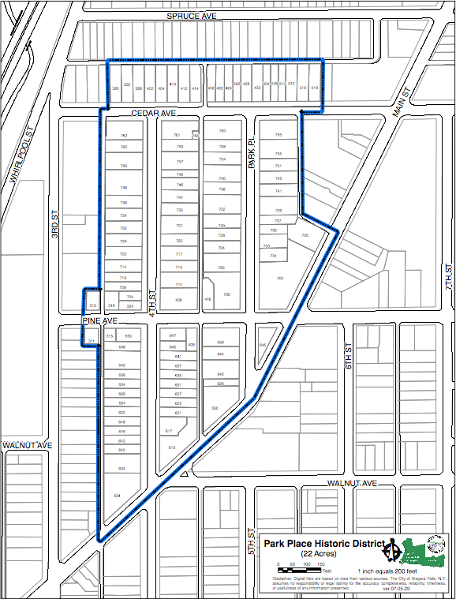
The present district was originally part of a larger residential neighborhood which included the east side of 3rd Street and Main Street (which was originally developed as a residential area). This portion of Main Street connected the early villages of Niagara Falls to the south and Suspension Bridge to the north and contained large mid to late 19th century residences with substantial lots having notable setbacks and landscaping. Main Street has since evolved into a commercial district with a few remaining traces of the former residential buildings still existing. Although the district is and has been mostly residential; there are examples of buildings being used as tourist homes (600 block of 4th Street), bed and breakfasts (Park Place) and office uses (Pine Avenue).

This residential neighborhood generally dates from the late 19th century and early 20th century. The integrity of this neighborhood is fairly consistent although some of the oldest buildings were demolished and replaced with newer structures in the early 20th century time period.

The district can be viewed as a microcosm of residential development in Niagara Falls representing a 75-year time period from the 1850’s to around 1930. There are four distinct layers of history and development represented.

Layer 1: 1850’s workers’ cottages on Cedar Avenue

Layer 2: late 19th century middle income residences, including single family, multiple family, flats, boarding houses and tourist houses. These buildings are evident along Cedar Avenue and the 600 block of 4th Street.

Layer 3: turn-of-the-century upper income residences on Park Place built for the early leaders of industry and commerce in the community. These buildings share a consistent size, material, setbacks and notable detailing

Layer 4: the 1920’s homes built for middle level management and professionals on the 700 block of 4th Street

Read full article on the Niagara Historic Preservation’s website by following this link:  http://www.niagarafallshistoricpreservation.org/node/19

It All Started With a Kite by Robert Giordano

Most of us have heard the story of Homan Walsh, the 15 year old that was able to cross the Niagara River with a kite line in 18 — that started the construction of the first suspension bridge across the Niagara Gorge, but no one seems to know about the engineers that repeated this feat to start construction of the underwater weir in the Upper Niagara River during the 1940’s.  One of the more interesting developments on the Niagara Parks system in 1943 was the construction of a barrier by the Ontario Hydro Electric Power Commission and the US Army Corps of Engineers in the upper reaches of the Niagara River above the Falls. This was built to divert a greater share of the water so the plants on the U.S. side would obtain the water to which the United States was entitled and to improve the appearance of the Horseshoe Falls

I came across the story of the men of DeCew Falls Development (this was a power station in St. Catharines, Ont. that supplied power to The City of Hamilton) The article was credited to George Bailey (of the Niagara Parks Commission) from a 1943 article in the Hydro News, the journal of the Ontario Hydro Electric Power Company and their use of a box type kite (a rather LARGE box kite, not like the one pictured in the photo above) to lay a line across the river that was used to start construction of a submerged weir in the rapids above Niagara Falls.

I have contacted DeCew Falls Development, N P C, Ontario Power, and Hydro One- (predecessors to the Ontario Hydro Electric Power Corporation). I have been informed that the archives for the Ontario Hydro have recently closed. I learned that while Hydro One got the Archives (which recently closed) OPG maintains the Corporate Library, which has the holdings of Ontario Hydro and the OHEPC.

I was able to confirm that a document exists that explains the use of the kite for this project. The document mentions the engineers of Decew being involved in this project, as Decew II was built as a result of wartime power requirements.  The document is titled “Niagara River Submerged Weir”  and dated for March 1943. Apparently it was issued by the USACE- Buffalo District. The use of a kite is confirmed in the document, however, no description of the kite is provided – just that it was used. The document is in the possession of the Ontario Power Generation Corporate Library in Toronto Ontario. The project is described as the “Niagara River Remedial Weir”, which was created by an agreement between Canada and the U.S. to divert additional water from the Niagara River (not to be confused with the International Agreement of 1950). I also have a copy of a staff newsletter from 1955 that mentioned the use of the kite and shows a couple photos.

I learned that the kite was used to build a submerged remedial weir that was used to raise the level of the Grass Island Pool- this was a predecessor to the International Control dam that controls the water in this area of the Niagara River. The story talks about building a cableway from towers that were erected on a man-made island that was built from the north end of Goat Island using a causeway. The other tower was on the Canadian side above the area of the river known as the Grass Island Pool. When the project was completed, they removed the causeway and the cables and towers. When the International control dam was built in the 1950’s, they used the small man-made island (known as “Tower Island”) as the terminus of the dam. Most of the secrecy of this project existed because it was a measure to provide water to the hydroelectric plants for wartime production.

The gentlemen that were involved in the work for both Governments include- Lieutenant Colonel George R. Goethals, District Engineer for the United States Engineering Department (Buffalo District Engineer Oct 1940- Dec 1942); Rodger B. McWhorter, Chief Engineer for the Federal Power Commission; Lieutenant Colonel Harland C. Woods, in charge of flood control for the U.S Army Corps of Engineers and Special Assistant to the District Engineer; David Forgan, Director of Construction; Otto Holden, Chief engineer of the Ontario Hydro Electric Power Commission, and Carl Gordon Cline, Senior assistant engineer of the Department of Mines and Resources, A. J. Eldridge of Columbus, Ohio, was consulting engineer on the construction equipment and supervised its installation. Other engineers from Ontaio Hydro that may have been involved include- Herman Hyland, Fred Burton, Ike Hicks and Walt Rennie. And finally, steel workers of the McLain Construction company including- John F. Torcello, D. Haskins, L. Byron, E. Miller, S. Nagy and S. J. Juliano.

David Forgan, Director of Construction retired in 1955- Herman Hyland who was also involved in this project was also retired by this time. Carl Gordon Cline C.E., M.E.I.C was born 25 September 1885 in Halifax, Nova Scotia. He received his C.E degree in 1922. Gordon died on 9 November 1969 at the age of 84. I was able to contact the daughter of C.G Cline. She confirmed that her father was involved in the kite flying.

The following is reprinted from a 1943 article in “Hydro News”, the journal of the OHEPC:

In unvarnished vernacular, the phrase “Go Fly A Kite” frequently implies sentiments not in keeping with literal interpretation. These four words, however, crystallized the idea, which facilitated the erection of a steel cableway, spanning a half-mile gap on the Niagara River at the brink of the rapids leading to the great Falls where a submerged rock weir is now under construction. Confronted with the problem of getting the first line across the river at this point, construction men on both the Canadian and United States sides of the International boundary gave much thought to the method which might be adopted. Direct crossing by a vessel was out of the question because of the swift currents and the close proximity of the rapids. Towing a line across would have involved taking it nearly a mile upstream from the cableway tower on the American side and then bringing the end of the line down the Canadian shore and past numerous land obstacles. There was also the possibility of the line being fouled by boulders in the river. Power lines and other obstacles precluded the possibility of using a plane, autogyro or dirigible, while balloons were unattainable. At the same time, the distance between the Canadian and United State cable towers was too great to come within range of a rocket gun. To surmount the various difficulties the possibility of using a kite was suggested as the most simple and economical method of getting the first line across the gap.

An investigation was immediately started and after a good deal of hunting much valuable information was unfolded on the history, eccentricities and functions of the kite. This research work revealed data on experiments, which have been made with large kites and, from this knowledge; it appeared that the “Go Fly A Kite” idea might succeed. The first job was the designing and building of a kite that would serve the purpose. And so, overnight, Hydro construction men at DeCew Falls Development became first class kite makers and produced a box-type, wind-powered exhibit that would have brought joy to the heart of the most critical schoolboy enthusiast. Measuring 7 feet 6 inches in height by 6 feet in width and 2 feet 6 inches in depth, it comprised a basswood frame and all the nainsook obtainable in Saint Catharines for the lifting surface. The controlling line was 1/32-inch piano wire – 6000 feet of it -while there were approximately 2,000 feet of trailing line terminating in a float and marked by colored streamers.

As part of the cableway, two 155 foot steel towers had been erected – one on the Canadian bank between Chippewa and Niagara Falls, and the other on an artificial island built on the United States side of the International boundary half a mile away. Everything was in readiness for the experiment. Then came several days of waiting for a favorable wind. When the day finally arrived, the men quickly took up their appointed positions. Because of the direction of the wind, the kite was sent aloft from a truck 2,000 feet downstream from the tower on the Canadian side. Many pairs of eyes watched expectantly as it soared and swayed in the breeze, the fine wire, almost invisible from the ground, hanging in a deep curve with its lowest point only a matter of a few feet above the swift waters of the river. Unexpected success was attained in the very first venture, the wire being carried from the shore across the gap without mishap.

The water splashes from the tossing float and the colored streamers enabled the waiting men on the island to follow the course of the fine wire and catch the kite that was guided behind the tower and hauled down. Next followed a sequence of tedious operations. First the fine piano wire was used to pull over another wire of greater diameter. The latter, in turn was spliced to a light cable one-eighth of an inch thick, which was used to bring over a quarter-inch cable. Eventually, a strong steel cable, two and a half inches in diameter, was pulled across to form the 2,605-foot cableway, which is now linked to the two steel towers. From there progressively heavier cables could be pulled through the water until finally the big two-and-a-half-inch cable could be strung from tower to tower to carry the bucket, which in turn would carry rock pieces weighing up to ten tons.

And so, the completion of this cableway was facilitated because Hydro construction men accepted the literal interpretation of “Go fly a kite”.

The submerged Grass Island Weir was composed of rock fill made up of very large blocks, measuring to 8 ton, of limestone with no bonding material, with a top width of about 12 m (40 ft.) and ranges in height from .6 m (2 ft.) at its mid-river terminus to 3 m (10 ft.) at the Canadian shore.  When completed, the weir was 1,455 feet (443m) long, extending from within 300 feet (91m) of the Canadian shoreline towards the shoal upstream from Goat Island. It extended out into the river for a distance of 1,840 feet from the Canadian shore, but did not begin right at the shore. A clear channel, some 300 feet wide, had to be provided and a distance of approximately 5 feet under the surface of the river had to be provided in order to allow a proper distance for ice clearance.  Because the top of the weir was to be five feet below the surface of the water, it was impossible to take the rock fill out from shore by truck or any other conventional method. The use of a floating plant with special safeguards was considered, but rejected as too hazardous. It was decided that a cableway was the answer, with a head tower with the hoisting machinery on one side of the river and its tail tower on the end of a rock fill causeway built out from the American shore, in shallow water.

The cableway construction was uniquely adapted to meet the conditions at the site and to the type of weir built.   To place the stone in the river the cableway was to be strung between two 47.2 m (155 ft.) steel towers, one on the United States side of the boundary – on an artificial island 0.8 km (0.5 mi.) out in the river just inside the American boundary – and the other on the bank just above Dufferin Islands at the start of the rapids between Chippewa and Niagara Falls. The head tower, located on the Canadian shore was about 10 feet above the tail tower. Each of the towers was to be mounted on a mobile carriage operating on parallel tracks about 160 feet long. With this arrangement, the towers propelled electrically- by two 25 HP motors mounted on the trucks, could be moved 80 feet from the center location upstream and down at a rate of 50 feet per minute. The mobility was needed to obtain the desired placing of stones in the construction of the weir. All of the controls and hoisting machinery were located on the head tower, which the tail tower could have been operated in synchronization or independently of the head tower. The cableway used for the construction of the weir was previously on an engineering project for the Conchas Dam in New Mexico and the Denison Dam construction project in Texas.

Construction of the submerged weir began in March 1942. To build this artificial island, the US Army Corps of Engineers built a 2,200-foot (671 m) causeway extending upstream from the eastern end of Goat Island.  Surveys made in 1941 indicated that the shallow depths on the shoal above Goat Island afforded the best location for an access roadway to the American end of the proposed weir. Construction of the causeway began in March 1942.  The causeway, a roadway of about 10,000 tons of riprap and quarry run stone was built along the ridge of the shoal for 2,200 feet ending in an artificial island for the tail tower of the cableway. The causeway was a single lane road embankment averaging about 5 feet high. Turnouts were provided in three locations for use of traffic passing. Tower Island is about 140 feet wide, 200 feet long and about 6 feet high above low water stage. It consists of a line of batter cribs to support the inclined front tracks of the tail tower and to take the horizontal thrust of the cableway; a line of rectangular cribs for the rear tracks; and a perimeter of heavy riprap, all filled in with smaller stone. In total, about 18,000 tons of stone were used.  The causeway and tail tower were finished by June 26, 1942.

Confronted with the problem of getting the first line across the river at this point, construction men on both the Canadian and United States sides of the International boundary gave much thought to the method which might be adopted. Direct crossing by a vessel was out of the question because of the swift currents and the close proximity of the rapids and Falls. The cable would have to cross nearly half a mile of deep, fast and dangerous water.   Towing a line across would have involved taking it nearly a mile upstream from the cableway tower on the American side and then bringing the end of the line down the Canadian shore and past numerous land obstacles. There was also the possibility of the line being fouled by boulders in the river. All sorts of suggestions came forth at this point, including the use of rockets airplanes and even an American Army blimp. This last method was favored in particular by the American Corps of Engineers, who were participating with the Commission on the weir project.  Power lines and other obstacles precluded the possibility of using a plane or helicopter.  At the same time, the distance between the Canadian and United State cable towers was too great to come within range of a rocket gun. To surmount the various difficulties the possibility of using a kite was suggested as the most simple and economical method of getting the first line across the gap. Whatever if was, it would first carry a light, fine wire across the gap. From there progressively heavier cables could be pulled through the water until finally the big two-and-a-half-inch cable could be strung from tower to tower to carry the bucket, which in turn would carry rock pieces weighing up to ten tons.

While the American engineers’ were making negotiations for a U.S Army blimp, the Canadian engineers were, literally, playing with kites. It all started when engineer Fred Burton remembered General Baden Powell’s use of the device in the South African war. An investigation was immediately started and after a good deal of hunting much valuable information was unfolded on the history, eccentricities and functions of the kite. This research work revealed data on experiments, which have been made with large kites and, from this knowledge; it appeared that the kite idea might succeed.  A few hours in the reference library added much practical and interesting information. A few more days for designing and building and there was a full-fledged kite. The complete outfit was in the hands of the Construction Superintendent at Niagara, exactly ten days after the idea was first formed.

Measuring 7 feet 6 inches in height by 6 feet in width and 2 feet 6 inches in depth, it comprised a ½” spruce or basswood frame, braced with piano wire and nainsook for the lifting surface. Everything was in readiness for the experiment. That same evening on Saturday July 5, 1942, a trial flight was made, with a certain amount of trepidation, but the kite behaved well. Then came several days of waiting for a favorable wind. When the day finally arrived, July 13, 1942, the men quickly took up their appointed positions. Because of the direction of the wind, the kite was sent aloft from a truck 2,000 feet upstream from the tower on the Canadian side. Many pairs of eyes watched expectantly as it soared and swayed in the breeze, the fine wire, almost invisible from the ground, hanging in a deep curve with its lowest point only a matter of a few feet above the swift waters of the river. The controlling line was 1/32-inch piano wire – 6000 feet of it -while there were approximately 2,000 feet of trailing line terminating in a float and marked by colored streamers. Unexpected success was attained in the very first venture, the wire being carried from the shore across the gap without mishap.

It turned out to be a complete success; the wire landing within a hundred feet of the designated spot. The water splashed from the tossing float and the colored streamers enabled the waiting men on the island to follow the course of the fine wire and catch the kite that was guided behind the tower and hauled down. Next followed a sequence of tedious operations- successive pulls of heavier cable took place without a hitch. First the fine piano wire was used to pull over 1/16 inch piano wire. The latter, in turn was spliced to steel aircraft cord one-eighth of an inch thick- by use of a hand winch, which was used to bring over a quarter-inch cable. Succeeding lines were 3/8, ½, ¾ and 1 ¼ inch wire ropes. Eventually, a special steel cable, two and a half inch locked coil, with a breaking strength of 345 tons was pulled across to form the 2,605-foot cableway, which was linked to the two steel towers. Pulling apparatus included a hoist drum mounted on a portable “Jenny”, a Caterpillar D-8 tractor, and the main hoist in the head tower. General rigging considerations required that the main track cable be pulled from the tail tower to the head tower. This cable with its special steel reel weighted 25 tons, and had to be moved from the railroad terminal to Tower Island over the Goat Island bridges, which had a safe load capacity of only 15 tons. A large timber reel was therefore built, on which half of the track cable was wound. An ensemble of hauling equipment, consisting of a truck tractor, two trailers and a second truck to provide tail tension, spaced a sufficient distance apart so that no two units were on the same bridge at the same time, safely made the crossing.

The first stone was placed in the weir on September 8, 1942, about 1000 feet from Tower Island. Work then progressed towards the head tower, for 200 feet. Experience on this section facilitated later operations, as the weir was extended at each end.

During August of 1942, the stone blocks were transported out from the Canadian side in a gondola car that was operated on a steel cable that was capable of supporting ten tons.  On a similar cable stretched between the two towers was another car that carried inspectors who with the aid of two-way, frequency modulated, short wave radio, communicated instructions for the placing of the rock to an operator situated in a control room mounted on the Canadian tower. Stone was dumped by taking in the slack in the dump lines at the point directed by telephone from the control station. Experimentation demonstrated that it was impossible to set stone directly in place because of the swift current, which metering showed ranged at up to 8 feet per second. Dumping from above the water surface was found practicable, as soundings indicated that the stone was not swept downstream appreciably. A story told by Carl Gordon Cline recalled the time that he and Mr. Woods were trying to see how far the current took the first big blocks that they were dumping into the water before they settled on the floor of the river.  So, they climbed into the big bucket with a radio with which to communicate with the operator.  Cline told the operator to lower them down until being radioed to stop.  He did, but half way down the radio stopped functioning, and the operator kept on lowering and waiting for the signal.  Before a man on the shore with another radio could tell the operator to stop lowering and start rising, Cline and Woods got a dunking in the River. Gordon’s reaction was – “next time I’ll give him all the instructions at once – to stop before they reach the water level!”

July of 1942– Newman A. Goldstein, of the advisory board of the Harbor Commission and a group of local residents proposed to convert the causeway and temporary island into a scenic attraction for the American side of the river. It had been suggested that the causeway and island could be made into a 1/3rd mile walk and a viewing tower constructed on the island for visitors. U.S army Corps of Engineers informed the group that the causeway would remain for about two years after the weir was completed and then be scheduled for removal. By September, the group abandoned these plans.

During 1945 and 1946, observation was made of the hydraulic and ice effects on the weir and additional rock was dropped along the weir where measurements indicated that holes had developed. By the summer of 1946, it was decided that the weight of the rock was sufficient and that no more rock need be dropped. This led to the decision to demolish the causeway and tower.  It was decided that the island however, would remain and be landscaped. The rock, that was eventually removed from the causeway, served to build up the mainland of the upper Niagara River west from the old hydraulic canal and on the East end of Goat Island. The rock was placed, covered with clay soil and vines planted. This was in compensation to the Niagara Frontier State Park Commission for the damage done to the shoreline attributed to the causeway being in place and the heavy use of Park roads and bridges. By the Fall of 1946, the cable was in the process of being removed by being hauled to the Canadian side, in an effort to relieve the Goat Island bridges and the roads of the Niagara State Reservation of the heavy trucking that was necessary to take it from the island. Demolition of the towers would follow in November. The towers, which weighted 230 tons and included a 10-ton crownpiece, and the demolition of the head tower on the Canadian side was under the jurisdiction of the OHEPC. The demolition of the tail tower was undertaken by the U.S . Army Corps of Engineers- Buffalo District, under the direction of John Torcello- with the actual work performed by McLain Construction.  Both towers were removed and stored at the U.S War Assets Administration warehouse in Cheektowaga, New York near the Buffalo Municipal Airport. It was reported that the tail tower was once used by the U.S Government during a dam construction project in Texas. The steel towers and cableway were again reused in 1948 for a project in Virginia.

The weir served its purpose until 1953 when the International Control Dam was built some 76 m (250 ft.) downstream. The artificial island remained and became known as “Tower Island” and it still exists today as a terminus for the Hydro Control Dam.

History All Around Us: The Colt House – 1018 Ontario Avenue


The Colt house was built in 1855, shortly after the village of Bellevue (former Suspension Bridge) was incorporated as Niagara City; in fact, one of the petitioners for this incorporation was Marcus Adams, an influential figure who, at the time the house was built, still owned the land on which it was constructed. The house was very probably built by Isaac Colt Jr., who gradually acquired the land around the house and willed the land and buildings to his daughter, or possibly by his son Leander, who was certainly closely associated with the house. The members of the Colt family were highly influential in the nineteenth-century history of the area.

The Colt House is located on the north side of Ontario Avenue between 10th and 11th Street.  [Please follow this link to the Niagara Falls Historic Preservation Commission for full story about the Colt House and many other fascinating historical places in the City of Niagara Falls.]